NATIONAL AWARD OF EXCELLENCE FOR PLANNING
Recipient: Taylor Cullity Lethlean with Peter Elliot Architects, Paul Carter and James Hayter and Associates
Project: North Terrace Precinct
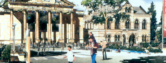
Focusing on the road reserve and its immediate environs, including laneway connections north and south, and major building forecourts, the study aims to create the basis for a vital northern edge to the city.
The intent is that this will link economically important areas in the city such as Rundle Mall, the East End and Hindley Street to the unique array of institutions and the river to the north, while also connecting a series of destinations along North Terrace, which together form the centre-piece of South Australia cultural and civic life.
The Concept and Design responds to the unique setting of Adelaide and in particular North Terrace and enunciated design principles for both the terrace as a whole, and the adjacent spaces which exhibit their own particular character. The design principles identified as critical to generating greater vitality, identity and accessibility along and around North Terrace are:
Thresholds the strengthening and enhancement of garden thresholds at the east and west ends of the terrace
Terrace Walk the creation of an uninterrupted green walk along the entire north side of the Terrace
City Edge the reinforcement of the northern ‘wall’ of the City grid
Cultural Heart an increase in activity in the cultural heart of the Terrace between Morphett St and Frome Rd
City-River links the creation of well used and safe links between the river and City
Terrace Vitality the creation of an urban environment which supports a rich social and economic life
The garden walk or double path still evident in Prince Henry Gardens is the principal remnant expression of the grand vision of the Terrace last implemented in the 1930’s. It is proposed to reinterpret this model to respond to contemporary needs and aspirations and extend it along the Terrace’s entire length. This approach creates a constant 23metre wide vehicle boulevard with a 25metre north pedestrian promenade and a 6metre south footpath.
The new north promenade is transformed as it traverses the Terrace’s different precincts and responds to their urban form and activities.
For a significant length of the Terrace the plan recommends native trees, to visually link to the adjacent parklands and river, to symbolise our contemporary relationship with the Australian Landscape, and to improve biodiversity in the city.
In the Museum Forecourt the plan recommends the collection and re-use of roof and stormwater; a principle which has been followed through with a bio-retention system and storage thanks being integrated into the subsequent design to supply up to 80% of irrigation water for this and adjoining spaces.
The concept master plan has grown out of extensive stakeholder and community input, including reference to consultation undertaken as part of earlier work by HASSELL in 1993. Displays in Rundle Mall and other city locations encouraged community comment which was integrated into the final plans. Stakeholder’s forums were regularly held to update adjoining landowners. In addition extensive consultation was undertaken with adjacent institutions including presentations to boards, meetings with directors and CEO’s and liaison with technical staff. The team reported to a sub-committee of the Capital City Committee with additional presentations to the full council of the City of Adelaide, State Cabinet, and the Capital City Committee.
On completion, the project was endorsed by the board of every civic and cultural institution on North Terrace, the North Terrace Sub-Committee of the Capital City Committee, the City of Adelaide, State Cabinet, and the Capital City Committee.
The principal consultant, landscape architect and urban designer for the project was Taylor Cullity Lethlean, lead by Kevin Taylor. The core design team also consisted of Peter Elliott Architects, artist Paul Carter, and James Hayter and Associates.
NATIONAL MERIT AWARD FOR PLANNING
Recipient: HASSELL Pty Ltd
Project: Ningbo
A vision for a new generation Chinese World City
Ningbo is the second largest port in China, benefiting from its proximity to Shanghai and Hangzhou, and its rapidly growing garment, hi-tech, and education industries.
Reflecting the rapid urbanisation of China, Ningbo is expected to double its population to 3 million by 2020.
Designing a new city centre in a country with a 4000-year history of city planning and design, raised important issues of cultural relevance.
“ Our concept blended traditional Chinese principles for city design such as ‘the magic square’, and ‘the field of nine divisions’, with well developed Chinese sustainable practices in agriculture, such as water management for flood control, irrigation and aqua-culture; and soil conservation and waste recycling. We then added complimentary and contemporary technology, in treatment of stormwater, sewage and other wastes, and generation of energy from the sun, wind and waste, to make a sustainable city for the 21st Century.”
The HASSELL concept allowed for a new city with about the same density as Berlin or Paris.
The detailed design concept for the new city centre was developed for a 7km2 (700ha) site within the overall expansion area. The HASSELL team modelled the form of typical buildings for each city block, mixing residential, commercial, retail and government uses with lively boulevards, civic spaces and an extensive park and canal system threaded throughout the city centre. The centre allows for a resident population of 100,000 people, to be housed at medium and high densities, taking advantage of the extensive park and water system which will generate high levels of amenity for new development.
Building envelope studies were developed in commercial, mixed use and residential areas of the city centre specifying height built and built form, including streetscapes, orientation and overall city from considerations.
Concept designs were developed and modelled in these dimensions for all the major civic buildings along the urban axis and all the sports and entertainment facilities on the knowledge axis.
Building design guidelines are accompanied with recommended sustainable building design guidelines for materials, energy use and water conservation, to compliment the ESD agenda for city infrastructure.
NATIONAL MERIT AWARD FOR PLANNING
Recipient: Coomes Consulting Group
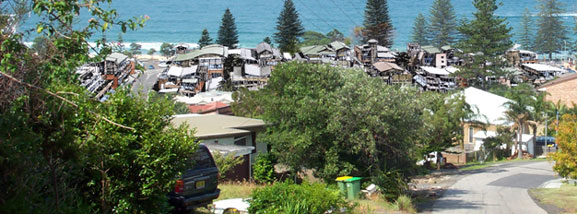
Project: Barlings Beach
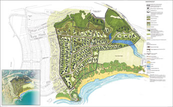
This project demonstrates the key role that Landscape Architects play in planning and designing developments that respond to and enhance the environmental qualities of an area.
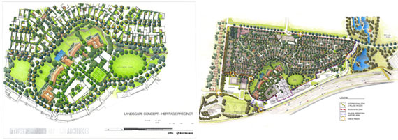
Coomes Consulting Group was the key consultant for the preparation of a masterplan for a high quality, low density, integrated residential development, located on a 33.5 ha parcel of coastal land, at Barlings Beach, Tomakin, NSW. The unique coastal setting, together with the complex and varied landscape character of the site, presented the team with an array of environmental, physical, cultural and socio economic challenges, requiring a sensitive approach.
The masterplan for Barlings Beach derives from a process balancing technical research and analysis, along with broad consultation to inform an urban design concept and detailed design. The scope and composition of the project team contributing to the masterplan married a broad range of skills and experience, encompassing landscape architecture, planning, urban design, and architecture. At a technical level the project team commissioned site-specific research with regard to archaeology, culture and heritage, flora/fauna, soils and water quality. Where findings warranted further investigation, additional research was undertaken.
From the outset, the design process sought to ensure that all relevant public and private interests in and expectations of the development of the land were acknowledged, considered and integrated into the masterplan.
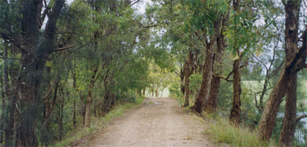
A sensitive approach will be taken in the planting of local natives in the appropriate zone, in order to respect the different vegetation communities existing on the site and the characteristics of each of these. Planting will be simple both in structure and species selections, primarily based on a lower storey of native grasses and sedges with an emergent tree canopy of predominantly Casuarinas and Banksias. Shrub planting will generally be limited to uses such as screening, softening or barrier creation where required. The planting will also create a continuous landscape character through both the public and private realms, with a sense of the buildings and roads being nestled into openings, in an otherwise continuous natural coastal landscape. This will be achieved in part by positive and descriptive landscape design guidelines, coupled with covenants requiring the use of mainly local plant materials.
Open spaces and parks will be strategically located to protect the dunes, the Aboriginal Place, the escarpment, swamp areas and creek environs, whilst also facilitating view corridors, connections and buffers. Boardwalks will allow sensitive access along and across the dunes, and to the beach area, meeting the objective of ‘treading lightly’ on the landscape. Open space and parks will be enhanced with informal feature elements reflecting a coherent palette of materials and elements. Other landscape elements will be designed to ensure consistency with this, and will aim for simplicity in form. The overall approach will be to use natural materials that blend in with the landscape. Several key landscape locations however, will be signified by strongly coloured walls, in order to create focal points within the landscape.
NATIONAL MERIT AWARD FOR PLANNING
Recipient: John Mongard Landscape Architecture
Project: Toradin Village
Toradin is strategically located at the only place where the South Gippsland Highway meets the waters of Western Port. The Village is located 65 kilometres south east of central Melbourne.
The tremendous population growth potential of Melbourne’s south eastern corridor will provide new opportunities for Tooradin to perform a unique niche role as a place for day trips for the nearby suburban population. The Tooradin Village strategy seeks to capitalise on this by the careful planning of new activities including a waterfront promenade, a regional tourism information and interpretation centre; and eco-tourism ventures focused around walking and bridle trails.
The Strategy aims to re-position the development approach to Tooradin as a model for the whole of Casey City The re-positioning has emerged in response to the involvement and visioning of the local community who helped shape the Strategy. Above all else, the Tooradin people are passionate about improving the area’s natural environmental qualities.
Traditionally, Tooradin’s development has pushed out indiscriminantly into the surrounding rural landscape. As a result, local ecologies have been compromised and natural systems disrupted. The Strategy reverses this past development model and aims to actively rehabilitate the local ecology and promote sustainable development. The design philosophy is one of the local environment filtering through into Tooradin Village, instead of the Village pushing out endlessly. For example, the Strategy proposes a series of new linked wildlife corridors within the Village to help bring back Tooradin’s natural qualities, and has also defined an ecological limit for expansion by creating strong regulatory edges. Above all else, the starting point for all new development in Tooradin will be the importance of improving the environment.
Faced with the imminent need for a sewerage system, Tooradin could easily triple its population in a short-time. How was this change to be managed to prevent destruction of village life? JMLA worked with Council and a project managed team of consultants covering ecology, infrastructure, cultural heritage, safety and access, geology and agriculture and community planning. Detailed studies were carried out over a year-long period.
JMLA worked with Council to modify zonings, land-uses and provide future lot-structures to ensure a sustainable future village. Developers are following these templates, creating village lanes in the traditional village grid, and incorporating water sensitive swale drainage and wildlife corridors
NATIONAL MERIT AWARD FOR PLANNING
Recipient: Pittendrigh Shinkfield Bruce
Project: Wilson Brothers Community Centre
The need to engender trust and cohesion through careful community consultation can be of crucial importance to the outcome of any development process.
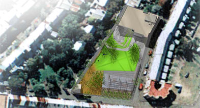
No project demonstrates PSB’s capacity in this regard more vividly than our handling of the politically sensitive Wilson Bros site in Sydney’s Redfern. This 3,000 square meter area of factories rezoned as ‘open space’, for the community, sits adjacent to an area known as The Block – the heartland of urban Aboriginal people and an important focus for Aboriginal Redfern.
We have since gone on to document the results, and to design and develop the park and community centre. The final design integrates space for outdoor performance, community markets and festivals, for gathering and storytelling, informal sports and children’s play. An accompanying management plan, with staged reviews, is designed to ensure continued equitable access to the Centre by all members of the community.
It contains a strategy for performance review and reassessment of all community needs in an appropriate timeframe: internal reviews should occur in the first five years, plus a major external review of the community’s needs.
The landscape architect’s solution for an equitable and workable urban park in an area often sensationalised in the media as a dangerous place troubled by drugs, unemployment and poverty, honoured an open and inclusive consultative process.
The high fences and “secure”, segregated spaces that were advocated by a small but vocal minority are absent. Both the consultation process and the resultant masterplan are open, legible and readily surveyed. They are non-prescriptive, overlaid with opportunities for creating a yet to be discovered ‘United Nations for Australian Aborigines’ and a place for a meeting of the disparate communities of Redfern.
In this bold attempt to provide an open, equitable facility for the people of Redfern to stamp as their own, our role in the process was central and defining. The ultimate success of any proposal at the site is impossible to predict. But as a result of the opportunities created for expression and interaction, a process of community building and healing has occurred and a feeling of good faith generated. A positive start has been made.
NATIONAL MERIT AWARD FOR PLANNING
Recipient: Brisbane City Council - City Design in association with HASSELL
Project: Rocks Riverside Park
Like all great landscapes, theRegional Riverside Parkat Seventeen Miles Rock embodies the major pre-occupations of its time.
Progressively, it remakes a polluted, post-industrial site on the Brisbane River as a landscape where the community explores what issues of cultural and environmental sustainability mean in practice. These issues are manifest in the park’s distinctive contemporary forms, its program and its management. While specific to this place, they provide models for sustainable practice in sub-tropical cities and regions elsewhere. At Riverside, concepts of sustainability are made tangible.
Hassell were engaged by Environment and Parks (Urban management Division) to prepare initial concepts and Master Plan Documentation for the Rocks Riverdale Park. The first Mater Plan was completed in 2000.
A change in design direction, land acquisitions and the refinement of the budget post March 2000 indicated that the initial master plan document would require major review prior to proceeding to design development and project implementation. City Design – Landscape Architecture was engaged to undertake this work.
The commission required re-design of the major areas, ensuring the creation of an innovative and sustainable contemporary park tat reflected planning constraints and opportunities.
City Design – Landscape Architecture in conjunction with Hassell, developed the revise Master Plan and supporting planning strategies to guide the detailed design of the project.
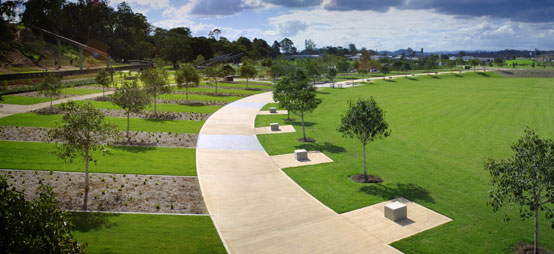
Rocks Riverdale Park covers an area of 26 hectares with 800 meters of river frontage within the Seventeen Mile Rocks reach of the Brisbane River. The site provides green linkages to the west along the river, and to the south and east over the bushland escarpment. Ten hectares have been intensively developed as the contemporary park setting. Major site elements include the Brisbane River, the natural bushland escarpment, industrial artifacts, remnant coral stockpiles and open space areas.
A project of this size and complexity provides significant opportunities for innovation in open space planning. From the outset, the integration of responsive environmental design provided a framework on which the Master Plan was developed.
NATIONAL MERIT AWARD FOR PLANNING
Recipient: Aspect Sydney
Project:Woollondilyl Vision 2025
Wollondilly Vision 2025 establishes nine key visions statements, encompassing vegetation and ecological protection, healthy waterways, protection of rural environments, and towns, maintaining rural activities, establishing green recreational corridors and social aspects.
These vision statements are then divided into three categories, - major outcomes, key strategies and risks. The first two categories establish clear results and ways to achieve these. The risk categories establishes likely results if these strategies are not undertaken.
Community consultation was undertaken in tandem with analysis to establish what the community valued in Wollondilly. The result was a community response that coincided with the preliminary vision statements devised by the project team. The community focused on protection of rural character, protecting and building on existing town structures and protection of native vegetation communities and waterways. Subsequently the 9 vision statements were presented back to the local community as part of the consultation process. This Risk category was particularly effective during the consultation period in identifying to the local community the results if the strategies are not undertaken.The 9 Vision Statements are supported by a series of town visions and strategies, for the principal towns in Wollondilly shire. Whilst the visions provide clear shire-wide outcomes and strategies, the town visions provide a pictorial approach to how these strategies can be translated on a local, detailed level.
The town plans identify town limits and boundaries, opportunities for consolidated residential development, environmentally sensitive areas for protection and opportunities for recreational links and corridors. They translate written proposals into clearly legible, understandable proposals that can be implemented on a town level. The town plans were supported by a series of individual town visions, strategies, and risks. These plans were recognised as guiding documents only, and would require further detailed studies to explore and test the proposals.
The town plans provide a physical plan, with which Council and the community can refer and respond to proposals and changes. The final stage of the consultation process allowed for community review and input into the individual town strategies.
Wollondilly Vision 2025 is unique in that the client had the initiative to instigate a thorough guiding strategic approach, that would provide the basis for protection and sustainable development in there area. To date, councils have struggled with the incremental decisions of other authorities, groups and stakeholders, with an unsupportive, ambiguous planning framework that is reactive rather than proactive. The vision enables communities and council to employ effective tools to guide the future of their towns and lands.
NATIONAL COMMENDATION AWARD FOR PLANNING
Recipient: Tract Consultants
Project: Commonwealth Games Village 2006
In 2001, The Village Park Consortium (comprising Australand and Citta Property Group Pty Ltd) appointed Tract as project landscape architects and urban designers for their 2006 Commonwealth Games Village tender submission to the Victorian State Government. In October 2002, the Consortium’s proposal was selected by the Government as the plan which best delivered the critical functional requirements of the Village while meeting a wide range of financial, environmental and social design criteria.
To select the preferred site and developer for the Games Village, the Victorian State Government called for ‘Expressions of Interest, followed by a ‘Request for proposals’ from the ensuing shortlist of proponents. Following their review of entries, the Government selected the proposal prepared by the Village Park Consortium to develop the Games Village in Parkville on the site of the former Royal Park Psychiatric Hospital.
Following their selection, the Village Park Consortium design team entered into a period of Master Plan refinement culminating in a comprehensive submission to the Commonwealth Games Planning Advisory Committee. At the time of this submission, the State Government initiated a formal consultation process providing the opportunity for the Community to respond to the design. Melbourne City Council and Moreland City Council were important participants in this process. During their review, the Advisory Committee called upon team members to present various components of the design and provide supplementary information as requested. In August 2003, after considering the Advisory Committee’s recommendations, the Minister for Commonwealth Games advised the Village Park Consortium of his determination.
The Commonwealth Games Village is a highly visible project, which has and will continue to be subject to intensive review on multiple fronts. As a result, the project has the capacity to demonstrate to a large audience the ability of the landscape architect to establish the overall Master plan “vision” and then guide that vision through a multitude of obstacles to realisation. As a high profile project, which is also committed to setting design, environmental and social benchmarks, the Games Village provides an important professional example and a vehicle for learning on many levels. Tract Consultants were appointed as landscape architects and urban designers in 2001 at the project’s inception and will continue in this capacity until its completion in approximately 2012.
NATIONAL COMMENDATION AWARD FOR PLANNING
Recipient: Pittendrigh Shinkfield Bruce
Project: Terrigal Town Centre
Visual quality is a key component of the character of most coastal towns in New South Wales. Communities value access to views and are increasingly demanding planning controls that protect visual resources. Yet, the visual environment is a resource that is often given scant regard by the planning profession.
The NSW coastal town of Terrigal, (which is set in a natural amphitheatre known as the Terrigal Bowl) is no exception to this and is growing rapidly. The attraction for tourists and new residents is its relaxed, casual atmosphere and natural beauty, but this has been increasingly compromised by traffic congestion, deteriorating buildings and a tired public domain.
Initially appointed to improve the beachfront, by masterplanning and detailing a new public domain, the landscape architects recognised the inadequacy of existing planning controls to guide future development, not only along the foreshore but throughout the whole town. In subsequently preparing a Strategic Plan for Terrigal Town Centre and the surrounding bowl that defines its character visually, we have massively increased our role and responsibility in reshaping Terrigal’s future, both at the large scale and in the fine detail, where we were engaged to provide guidelines and define limits for development for the Terrigal town centre and its residential hinterland.
Wide-ranging recommendations were developed to promote scenic quality and amenity in the town centre and maintain its “village style”. Problems relating to occasional flooding, old public facilities, the uncoordinated form and design of buildings, car parking and traffic movements and congestion were also addressed.
Other strategies were designed to enhance the unique character of the beachfront and retail precinct, to encourage pedestrian ownership of it, and to connect them both physically and visually as the town centre. The foreshore and other public areas were considered in terms of developing a new and interpretive public domain where materiality and form are representative of Terrigal’s histories and the unique qualities of its natural coastal formations, in particular the tessellated patterns of the ocean rockshelf.
The Plan itself tested a series of building height scenarios for their impacts on ocean and forest views. An economic analysis was then carried out to allow Council to make an informed decision as to what development scenario would protect local visual quality yet provide sufficient economic incentive for development.
NATIONAL COMMENDATION AWARD FOR PLANNING
Recipient: Christine Murphy Landscape Architects
Project: Rouse Hill Regional Centre
Caddies Creek Landscape Management Strategy
The proposed Town Centre occurs in an area rich in biological and cultural diversity including endangered ecological communities and Aboriginal Heritage with varied landscape character.
The proposed Caddies Creek Corridor will integrate the future development of the Town Centre with regional Trunk Drainage whilst protecting these identified environmental assets. The aim of the study was to provide a strategic framework and management guidelines for future land managers, developers and designers.
Significance of the project/special factors:
1. Early involvement of the landscape architect in the planning process.
2. The landscape architect’s methodology which included”
3. review of all previous studies and recommended conservation management strategies.
4. analysis of site values
5. assessment of development constraints.
6. major issues identified through consultation with stakeholders.
7. principals and strategies developed in response to these key issues
8. the landscape structure plan illustrates how the principals and strategies can be applied to the development control process.
9. the visual presentation of biological, ecological and heritage legislative requirements summarized on the constraints plan. This assisted the stakeholders to recognize the implications of their specific requirements on this integrated development.
10. The process, culminating in the structure plan and associated report, enabled the client to incorporate best practice environmental management principals into the development control plan.
This landscape strategy has been used by the Department of Urban Affairs and Planning in the preparation of the Rouse Hill Regional Centre Development Control Plan. It will assist the client in meeting the expectations and responsibilities of all stakeholders and the broader community. The report acknowledges the inter-relationship between development, drainage, ecological and recreational requirements and will be a valuable reference document for Landscape Architects and others involved in the development process.
Client:Department of Urban Affairs and Planning, Land Management Branch.
Stakeholders/consent authorities:
Sydney Water Corporation
Department of Land and Water Conservation
Baulkham Hills Shire Council
National Parks and Wildlife Service.
Consultant Landscape Architect:
The Landscape Architect’s role was critical in collating and formatting the ecological and environmental controls as a basis for planning and development of the new town centre.
Base documents supplied by:
Aboriginal Heritage Management Plan
Flora and Fauna Management Plan