NATIONAL AWARD FOR DESIGN
Special Jury Citation: For environmental approach to planned residential estates
Recipient: Cardno S.P.L.A.T.
Project:Stradbroke Domain
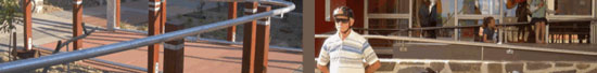
The brief was to remodel the site to retain the beach holiday essence and leafy character, yet package it anew in line with the high environmental and holiday experience standards expected by the new generation of North Stradbroke Island residents and regulars.
The existing trees are the cornerstone of the 2ha site. Small ‘beach shacks’ and ‘villas’ nestle amongst the trees in a streetscape-like arrangement, sensitively detailed to create a resort seemingly carved out of the natural bushland. Our role as landscape architects was to guide the design development along paths leading to ecological integrity.
Special Factors:
- Tree retention - Large established trees have been retained in extraordinarily close proximity to buildings, driveways and pathways.
- Road Frontage - Completely landscaped to visually and ecologically integrate the Domain with both the bushland and the streetscape.
- Materials palette - plants 100% indigenous to Point Lookout. Sand tracks (reminiscent of beach accesses), crushed Island stone paths, roads and swales, reused granite stones. No imported topsoil and no ex-ground trees.
- Stormwater treatment - All storm water returns directly to the water table via gravel soakage pits or swales (rock-lined or grass).
- Revegetation - The ‘embankment’ behind the site was degraded with weeds including many garden escapees from the original Tourist Park. These were removed and approximately 300m2 underwent supplementary planting
NATIONAL AWARD FOR DESIGN
Recipient: Convic Design Pty Ltd
Project:Cairns Esplanade Skatepark
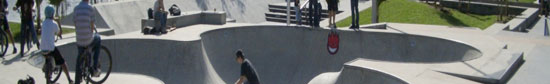
The Cairns Esplanade Skatepark is not only Australia’s largest all ages public sporting facility of it’s type, but an important national and international community resource challenging the perception of what skateparks are and how they can integrate into the public domain.
The Cairns Esplanade Skatepark is the first skatepark of its kind blurring the lines between traditional skatepark infrastructure and landscape. Echoing the alignment of the new esplanade three skatepark plazas push through the landscape, rising to form and deform the upper tiers of the adjacent beach volleyball court viewing seat wall. Dissected by skateable paths, the plazas are connected back to the esplanade creating defined entry points to the facility. Perched and banked lawns arise in the wake of this concrete latticework, offering passive viewing and refuge areas able to be utilised for event days and competition, whilst addressing existing trees and services.
Adjoining an internationally recognised migratory wader bird habitat and in close proximity to a declared fish habitat area, the foreshore of the northern esplanade overlays soft marine clays requiring the area to be preloaded before excavation works could take place. A major influential factor in setting the levels of the skatepark bowls and in turn the whole facility was to avoid any disturbance of the underlying acid sulphate soil. Adhering to Councils philosophy of no net environmental impact – any detrimental impact is compensated by an equal or greater beneficial impact.
As a non-traditional area of the landscape architecture, Convic Design is an international award winning design practice that contains a diverse mix of athletes and professionally qualified designers who work collaboratively on the likeminded goal of developing the most innovative, integrated design solutions for clients around the world. Convic Design would like to raise the Cairns Esplanade Skatepark as a example of New Directions In landscape Practice.
NATIONAL AWARD FOR DESIGN
Recipient: EDAW
Project:Ipswich River Heart Parklands
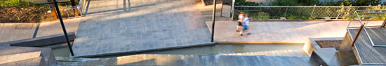
Sensitivity and understanding of the Bremer River’s significance to Ipswich and its residents has enabled EDAW to transform a once neglected river edge into the heart of the city.
As lead design consultants for the $5.4 million project, EDAW recognised and harnessed the social and geographic importance of the river to revitalise it from an underutilised and unsightly urban river precinct into a vibrant, multi-use public space.
With the Ipswich region facing a trebling of its population over the next 20 years, the River Heart Parkland represents the first stage of the Ipswich River Heart Parklands project – a bold vision by Ipswich City Council to re-focus the city towards its historic riverfront. The Parkland is significant for a number of reasons:
It acts as a catalyst to the transformation of the Ipswich Central Business District and supporting existing retailers in the City Centre;
- It provides high quality open space for an increasing population of inner city residents;
- Its sets a high standard for future public domain and open space developments within the city;
- The parkland interprets the site history to create a powerful place that is distinctive and has significance to the local community;
- It provides permeable and usable urban connections along the riverfront to public spaces to the east and west; and
- It helps reconnect the city to the Bremer River, the lifeblood of the area in the past.
The design evolved from early master planning work undertaken for the client, which considered the Bremer riverfront in the context of the developing city heart. Early concepts were developed and these were tested at community meetings and a public display. Feedback from the community, stakeholders and council was then used to develop a preferred master plan.
The final master plan and Stage 1 plan was developed within tight budget constraints that had to allow for a large number of unknown costs on this very challenging site. For instance, the past history of use of the site was known, but the detailed location of possible former structures and the impact of many years of uncontrolled fill placement were unknown. The budget for this first stage had to accommodate contingencies for some of these hard to predict constraints.
The true test of public domain is the public’s enjoyment of a space, and since its opening in February 2007, the Parkland has been enthusiastically embraced by all sections of the community for its richness, quality and sense of place. The resurrection of this portion of the river has reinvigorated people’s use and expectations of their public domain as a place where they can feel safe, comfortable, accessible to everyone and therefore highly valued.
NATIONAL AWARD FOR DESIGN
Recipient: EDAW
Project:Murrays Beach, Wallarah Peninsula(Stages 1 to 7, Lake Sector)
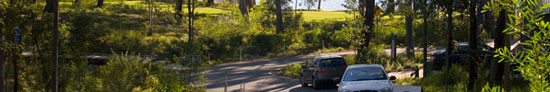
Wallarah Peninsula is a 600-hectare area of land located some 125 kilometres north of Sydney in a spectacular location of elevated coastal land, bound by the Pacific Ocean and Lake Macquarie.
The $500 million primarily residential Murray Beach development takes in all components of sustainability – environmental, social and financial. Since Stockland acquired the land, 180 of the 600 hectares have been transferred to the NSW State Government to create Wallarah National Park.Since 1995, EDAW has provided extensive ongoing master planning, management planning, concept development, development application and detailed landscape architectural documentation for Wallarah Peninsula, with a strong focus on the environmental quality of the landscape and the lifestyle of its end users.
Murrays Beach (Stages 1-7, Lake Sector), sited on the eastern shore of Lake Macquarie, is the first stage of works to be constructed at Wallarah Peninsula, providing a benchmark for the development and implementation of future stages.
Such an environment requires careful planning, design and management to ensure maintenance of the inherent quality of the landscape as a long-term community asset. The methodology and approach to design was driven by a strong environmental philosophy, supported by fundamental landscape and urban design principles.
The densely vegetated site has varied topography and magnificent scenic outlooks to Lake Macquarie. It comprises a Village Centre, Sales and Information Centre, Village Green and lakeside residential lots, which will form the focus of the Peninsula’s Lake Sector development.
The development intent and approach used at Murrays Beach, to the best of our knowledge, is a first for New South Wales. The approach involved a comprehensive analysis of the site’s flora and fauna, landform and hydrology, using this information to dictate road and landscape design and lot layout, including the siting of building envelopes within individual lots. An indication of current success is the retention of over 70% of the original trees onsite within this stage of development.
Murrays Beach is considered a best practice and pioneering exemplar of how a residential estate with outstanding ecological values and high sensitivity can be developed. To date, it has won both Sustainability and Green Smart Industry awards for the client, Stockland.
NATIONAL AWARD FOR DESIGN
Recipient: James Mather Delaney Design
Project: Glebe Foreshore Walk

The Glebe Foreshore Walk introduces substantial marine habitats into a highly urbanised part of Sydney whilst responding to a rich industrial heritage context. It will form the western most segment (over two kilometres long) of the City of Sydney’s planned foreshore walk, stretching from Woolloomooloo to Rozelle Bay.
The Glebe Foreshore Walk connects existing and new foreshore open space by means of a subtly articulated path. The path connects newly formed spaces, access to the water, newly created ecological habitats, items of heritage and archaeological significance and WSUD bio swales.
The sea wall along the foreshore was in many places unstable and suffered from inundation and overtopping. In inserting a new walkway two technical requirements provided the overriding constraints, firstly NSW Maritime requirement that the pathway be some 400 mm above the existing sea wall level, and secondly Council’s requirement to provide maintenance vehicle access to the length of the walk.
The design aimed to maintain the integrity and character of the existing sandstone sea wall by stabilizing it and inserting new walls as necessary behind the existing wall. This solution created a seating edge along the shore and clearly added a contemporary layer to the historical ones.
Careful attention was paid to the site context at the detail level, design decisions were informed by material changes, inflections in walls, transitions in sea wall profiles and other subtle shifts in the natural and engineering features found on the site. New spaces were grafted into and around these points of difference. The new sea wall and path configuration, alignment, materiality, width and hierarchy shift in response to existing features and the technical requirements.
The Glebe Foreshore Walk provides pedestrian and cycle access through a varied landscape experience along the edge of Blackwattle Bay and Rozelle Bay. The walk incorporates a boat launching beach, a pontoon (currently at tender) and a newly created mangrove habitat at its western extremity.
Around the stormwater canal the existing salt marsh community, has been encouraged to expand through subtle levels modulation. In Bicentennial Park pathways have been refurbished, unhealthy growing conditions repaired, fig trees lifted and replaced. At the eastern end of Bi-Centennial park a 14 metre concrete stair allows access to the water.
This destination point nestled at the edge of the mature Moreton Bay Figs where the sea wall changes, forms the junction to several paths and the location of a stormwater bio-swale. To the east of the Moreton Bay Figs a lowered viewing area is inserted where the sandstone sea wall shifts from a battered arrangement to a vertical one, the area presents a variety of seating options and a vantage point to the Anzac Bridge.
At a formerly inaccessible section of the Walk known as the Anchorage a new small park is created comprising of two Figs, a lawn and a backdrop of endemic plantings. Here the path is deflected to make room for a stair that is cut through the existing sea wall to allow access to a build up of sand exposed at low tide and a set down area providing seating at the waters edge removed from the main pedestrian flow.
The Walk narrows as it moves east past the archaeological site of Stride’s Yard where new walls and stairs to the water have been carefully inserted to reveal an old slipway.
Around the headland upon which Bellevue House sits the new path has been raised by 400-600mm and set back from the old sandstone sea wall. Precast units support the new path whose alignment shifts in response to a narrow sandstone sea stair and existing trees. In front of the seaside villa, “Bellevue”, vegetation is cleared to re-establish a relationship between house and harbour, whilst massive sandstone walls retrace a mirrored version of the former water edge.
The path from the foreshore to the villa turns back upon itself as it climbs the embankment drawing the visitor’s attention to the breadth of the scenery. At the top of the stair a sandstone path circumscribes a lawn planted with a Hoop Pine. On the foreshore a stair provides access to a sandstone ledge exposed at low tide and a ramp leads to a pontoon (currently at tender). The arrangement of the new precast wall, the sea stair and new sandstone wall plays off the overlapping lines of the rock shelf, sandstone sea wall, and industrial concrete edge (pre 1970’s).
To the south of Bellevue, a bio-swale formed by tiered pre cast concrete wall units treats water from Leichhardt street. The Foreshore Walk continues through Blackwattle Bay Park passing a large linear bio-swales, it then traverses the development at the old incinerator site, from where, in future stages it will connect to Pyrmont Bridge Road and the Pyrmont Fish Markets.
The project expressly sought to conserve and bring to attention the many different types of concrete around the foreshore by exposing their aggregates and contrasting them with new materials. Aggregates in the old concrete ranges from large sandstone rubble to river pebble and large basalt, each of these tells a story of aggregate availability and concrete making practice and each imparts a particular character to the place.
A constant element in the project is the 600mmx 600mm x 4000mm precast wall, which serves the dual function of raising the path to the required height above sea level and retaining embankments, bio-swales and higher ground where necessary. Specially designed end pieces terminate in a taper thereby causing the front surface to twist along its length.. The second set of precast units are L-shaped capping pieces designed to sit over sandstone clad walls which line one side of the sea stairs, these units are wide enough to provide seating on the landward side.
In contrast, the second edge to the sea stair is a 150 mm wide in situ concrete wall. The precast concrete contains a quartz rich sand mix that gives the units a warm colour and a slight sparkle that sits particularly well with the existing sandstone. The concrete offers a durable and cost effective compliment to the high quality sandstone necessary in the intertidal zone.
NATIONAL AWARD FOR DESIGN
Recipient: John Mongard Landscape Architects
Project: Kingaroy Cultural Precinct
Country towns are a threatened urban form. An ageing population coupled with migration to city and sea is leaving a rural landscape without jobs, prospect or vitality.
One of the major reasons people leave the country is because of a lack of cultural life – the events, art and vibrancy of the city. In these times of drought, attempts to regenerate cultural life in the country are extremely difficult. No money, no direction and no design expertise to make changes. In the context of this, Kingaroy’s attempt to create a cultural precinct is an important precedent for Australia’s future rural landscape.
Rural centres like Kingaroy are not famous for their cultural or environmental credentials. Years of Joh Bjelke Peterson have left the town with a good road, great farms and not much else. The emergence, embracing and implementation of a cultural precinct in such a town is thus a significant moment. JMLA were invited to provide ‘landscaping’ for a main street car park. After setting-up shop in town and undertaking community design, the plan changed, to build a town square and a cultural precinct. JMLA designed a town square and relocated the old railway station to provide a café/office/produce marketing space. The square was built where the town used to gather, before highways took over, next to the historic pub and where there used to be a symbolic gathering tree.
Another Set-Up Shop process expanded the plan to link the town square to the run-down history museum, near the grain silos on the edge of town. Community design process uncovered the need to relocate the town’s visitor and information centre, and also its dysfunctional art gallery. JMLA masterplanned a link building and courtyard between the old museum and the underutilised old Council Chambers. JMLA wrote a grant application and the precinct received $2 million dollars. After writing briefs for an architect to design an environmentally sustainable link building, JMLA managed the design and construction process. The outcome linked a new footpath to the town square, recycled the old Council Hall into an art gallery, built a visitor centre and craft/interpretive courtyard as the linking elements to tie into a renovated and re-interpreted historical museum.
The public spaces in the cultural precinct are the first improved streetscapes in Kingaroy since the 1970’s. They form a template for better quality walkways with shade, colour and stories. Highly reactive clay soils had damaged prior footpaths so new public spaces utilise long-lasting structural pavements. Farmers with red soil on their boots coupled with a chaotic arrangement of service pits on footpaths generated a paving pattern using red clay pavers in a patchwork pattern reminiscent of local agriculture. A cluster of disused or underused buildings have been relocated and refurbished. JMLA lined the old railways station to form an active edge to one side of the town square (O’Neill Square) and designed the building renovations and repainting. A public toilet and an events stage were incorporated into a square which faces the town’s last remaining historic streetscape. A second building was recycled into and art gallery and a third old building has been renovated to form a craft and choir activity space in the interpretive courtyard. The principle of recycling extended to using old railway timbers for benches and collecting local rural artefacts to interpret history and culture.
The theory behind the project was that a series of linked high quality public spaces accompanied by clustered and relocated buildings and facilities could allow emergent cultural and social patterns and groups to blossom. The implementation of this now evident – the town square provides daily lunchtime refuge, and has become the main venue for civic events and celebrations. The interpretive courtyard forms a public space around which visitors, crafts people and residents can engage. The interpretation tells about ecologies and hidden histories that had not been told before. The visitor and information centre incorporating the gallery, museum and craft areas is the new nexus for a broad range of cultural activities which shows that Kingaroy has creative people and who will enliven the town further as time goes by.
The project deserves citation in the areas of Local Government and small project innovation, since it shows that new important town activities can be created by a landscape architect working with local authority with little resources and utilising creative building recycling and land use facility replanning. It is a small project which began with a car park and emerged to consolidate a range of disparate functions and spaces, effectively binding them together to create a larger whole, The Cultural Precinct.
The project shows new directions for landscape architecture in the broadening of the landscape architects role to affect much more than just soft landscape and public space. By guiding the actual cultural facilities of the town and co-locating them, the project creates a nexus of activities and events which can actually generate public life beside and around newly crated public spaces. By using a community design process called Set-Up Shop, JMLA were able to really prioritise community needs and become champions for activating cultural life in town. The role of networking people and resources together is fundamental to the success of the project, overshadowing the conventional focus of drawing up plans. When community and Council leaders get excited and see opportunities to fix generational problems, such projects take a life of their own and become models for change.
NATIONAL AWARD FOR DESIGN
Special Jury Citation: Future directions in renewal of urban settings
Recipient: Oxigen
Project:Windsor Street Linear Trail
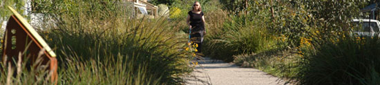
In 2007 the City of Unley completed construction of the Windsor Street Linear Trail, a 950 metre long, linear park that traverses in a north-south direction through the inner-city suburbs of Parkside and Malvern in Adelaide.
Staged over five years, the funding for the trail was a joint initiative of local government (City of Unley) and state government (Planning SA). Central to the success of the project was the care and commitment of the City of Unley and the local community. This has seen the project recognized nationally as an exemplar of urban sustainability and the creation of biodiversity within a suburban context.
Previously the site had been an aging, open concrete drain taking storm water and overflow from the Glen Osmond Creek. Between 1997 and 2000 The City of Unley constructed a closed, concrete culvert to reduce the impact of flooding to local residences.
In August 2000 Council endorsed a proposal to develop a native and indigenous linear reserve along the length of Windsor Street. Oxigen were engaged as the Landscape Architects for the project.
Extensive community consultation was carried out with an overwhelming response being in support of the Linear Reserve and the development of an indigenous plant corridor.
One of the core values of the reserve from the beginning was communication. Inventive, interpretative signage was designed to further enhance this unique project and to educate the local community and visitors to the area. The trail is always in use by local residents and the Council regularly holds walks and information days for schools and the general public.
The success of the Windsor Street Linear Trail has been formally recognized for its commitment to the establishment of biodiversity and the promotion and use of sustainable landscape practices through the AILA state awards and South Australian Civic Trust awards. Recently, Windsor Street featured on the ABC program Gardening Australia where it was able to reach interstate and overseas to a viewing audience of 30 million to promote and educate a wider audience in the principles of sustainability, biodiversity and the charter of landscape architecture.
NATIONAL AWARD FOR DESIGN
Recipient: RMIT University: Dr SueAnne Ware
Project:The SIEV X Memorial
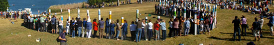
The SIEV X Memorial Project remembers those who drowned in the 2001 sinking of a ‘Suspect Illegal Entry Vessel’ when 353 refugees lost their lives.
It seeks to raise awareness of the urgent ongoing humanitarian crisis of refugee rights around the world, as well as the personal tragedy of those involved in this single instance.
The project was initiated in 2002 by Steve Biddulph, a psychologist and parenting author, Rob Horsfeld, a uniting Church Minister, and Beth Gibbings, an artist and project manager. In late 2002 they asked Dr. Sue Anne Ware to join them as their landscape architect.
A lack of media response and public concern surrounding this horrifying event prompted Steve and others to develop plans for a memorial to the victims. This was intended to recognise both personal and political issues surrounding the event and to work positively toward a better understanding of problems in order to avoid similar future disasters.
It was also an exploration of how we might be able to understand and assist in the grieving process of those directly involved, something which memorials have always sought to do, but which becomes even more difficult when trying to reach across the divide of countries, cultures and even the dividing lines of the law. It is also something that becomes more urgent as we struggle to find ways to usefully assist in helping refugees of global crises currently involving the largest mass movements of people in human history.
The Memorial project has involved people from all walks of life across the nation. In 2002, primary and secondary schools across the country were invited to participate in developing an idea for the design of a memorial place as a collective work of art. Over 200 entries were received and this collection toured capital cities throughout 2003 and 2004.
The momentum to build a physical memorial increased and Sue Anne’s involvement intensified. Ultimately a design proposal by a Year 11 Brisbane student, Mitchell Donaldson, was selected. This design included the creation of 353 poles – one for each of those that died at sea, adults and children, some with the sinking of the vessel and some after many hours in the water. Larger poles commemorate adults, while smaller ones remember younger victims. Numerous school children, church organisations, refugee rights groups, and various individuals participated by painting and decorating the poles.
The 353 original poles traveled across the continent to Canberra in 2006, to be erected on the fifth anniversary of the event. Refused permission for permanent installation, they were raised instead in a one-day ceremony on October 15th in Weston Park. The ceremony attracted people from all over Australia. Almost 300 poles arrived and were raised by 600 volunteers.
Over 1400 others arrived for the ceremony. Before and after the ceremony, the poles lay in situ while people wandered quietly amongst them, touching their surfaces. The poles were slowly raised for a period of silence. For about five minutes, the poles stood along 300 meters of lakeshore in a beautiful array. They were then gently laid on the grass once again.
This year, in a ceremony on September 2nd, the memorial poles were raised in Canberra’s Weston Park again. Throughout the project, Sue Anne has worked with different groups, prepared material to direct and encourage participatory responses, initiated and run supporting projects in Melbourne (for example the Artist’s Charity Auction), advised on siting, environmental and logistical issues regarding the pole production and installation and liaised with authorities.
This involvement by a landscape architect at all levels of a process from conceptual development to final installation, over the course of five years and across communities throughout Australia sets a new model of engagement by professional designers. It extends the range of skills and assistance for which landscape architects are recognised, as well as reinforcing the direct relevance of such assistance to the successful physical construction of environments – in this case a sculptural memorial in the public realm… a physical catalyst for social change.
NATIONAL AWARD FOR DESIGN
Recipient: Sinatra Murphy Pty Ltd
Project:Dandenong CBD Art Makers Project:Vessels of Light
Special Jury Citation: Cultural Relevance in Landscape Art

Vessels of Lightare a series of seven visual markers along a defined route between the Walker Street car park and Boyd Lane in Dandenong, Victoria.
They were developed in response to the Brief for the Dandenong CBD Art Markers Project, a temporary 5 year installation awarded to Sinatra Murphy through a successful concept and tender submission in 2006.
The vessels are inspired by the idea of ‘trade of culture’. Today the City’s multicultural population is continually adding to the cultural texture of the greater Dandenong area through the sharing of faith, language, cuisine and knowledge. Cultural experience is actively traded in daily life through restaurants and general retail. The ideas ofvesselandtradealso connect with Dandenong’s history of being a major trading centre for farmers and the City’s more recent identity as a significant manufacturing centret.Vesselis used a symbol of the City’s spirit.
The shape developed for theVessels of Lightis generic and inspired by cultural containers such as Turkish perfume bottles, Vietnamese candle boxes, and other exotic shapes that reference objects from ‘other places’. They are fabricated from fluorescent acrylic, brilliantly displaying colours from the national flags of countries represented through Dandenong’s ‘waves of migration’, reinforcing the unique nature of the vessels’ form.
Their contents isLight- the medium used to bring the visual markers to life through materials and construction methods that respond to ambient light conditions for a numinescence or inner-glow during the day, and programmed LED lighting to illuminate the core at night. They visually engage pedestrians and create a sense of fun and vitality, adding to Dandenong’s aspiration of creating a 24hr city.
The sevenVessels of Lighthave a consistent form and size, but vary in colour display. They are fabricated with 100% recyclable fluorescent acrylic sheets threaded horizontally over vertical acrylic cores. The 6mm sheet is computer cut and polished, creating an optically dynamic lamination. The vessels are 1.7m in height and 600mm at the widest part weighing approximately 200kg. They are position on walls of both council assets and private property. Their elevated positions have been determined by visibility, visual continuity and the 4.2 metre clear zone to be free from delivery transport. Stainless steel brackets hold the vessels from the wall and house the LED light fittings.
The project was conceptualized, designed, managed and supervised by Phin Murphy, Sinatra Murphy Pty Ltd. The vessels were fabricated and installed by AusPlastics, the brackets were fabricated by CP Engineering, and the LED supplied and programmed by Coemar Di Sisti. The project was officially launched on 24 July 2007.
NATIONAL AWARD FOR DESIGN
Recipient: Site Office Pty Ltd
Project:Raglan Street Parkland
Special Jury Citation:Small Project Innovation
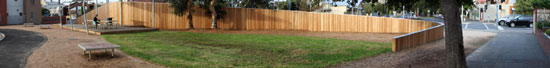
The original Raglan Street parkland is an example of one of the many ‘lost’ spaces within the urban fabric, spaces which, over time, have become separated and disconnected from the surrounding context.
This separation is the result of the progressive development of the city, characterised by an increase in quantity and speed of traffic and the resultant loss in amenity for pedestrians.
These spaces gradually develop when the traffic, noise and pollution reach such a level that people no longer stop and linger within them. While the public infrastructure often remains, such as planting and seating, the people do not, resulting in spaces that are empty and forgotten.
The brief called for the design of a neighbourhood park providing greater facilities and amenity for local residents. The project focused on suitable noise attenuation strategies that would increase amenity within the park, without disrupting visual continuity and pedestrian /bicycle circulation with the surrounding streets.
NATIONAL AWARD FOR DESIGN
Recipient: Sue Barnsley Design
Project: Barcom Park

The remaking of Barcom Park has come from the closure of two bounding roads, effectively doubling the size of this pocket park.
Whilst improving local traffic movement, servicing and emergency access from the hospital, the new park draws light, soft lawns, seats and gathering spaces into a new and engaging composition.
Ten metre road reservations have contracted to a four metre path along West Street and a share way on Barcom Avenue, where pixelated islands of bamboo, veil the shaded hospital perimeter. A diagonal path cuts through the broad and gently falling grass topography to connect these new, dedicated walkways.
Cupped either side of this stone path within the embrace and swelling of the grass, are two small curved seating pods, set at the quiet epicentre of the park. Each pod is formed by two bench seats of different radii, which draw the curve of the hospital into the composition and language of the park. Curved like apostrophes, the benches create a flow and dialogue between the pods that makes for conversation. At night these glowing rings brighten the interior of the park.
Crossing the base of the park a warping concrete wall and boardwalk edge a tangle of rushes and bracken that treat runoff captured across this steep site. Both retaining wall and seating bench, the wall folds from end, to centre, to end: from sloping revetment, to vertical wall, to cantilever. Where the wall projects into the share way it is clad in bead blasted stainless steel as both protection and adornment. Here a constellation of small, white led lights set in the boardwalk illuminates the underside of the wall. By day, this shadowed edge catches light reflected from the face of these lights onto the concrete, patterning the wall like water under a cliff.
Formed below the boardwalk the reed bed and bio purification basin is the most obvious expression of a series of water management initiatives within the park, which combine with gross pollutant traps, permeable pavements and swales to allow infiltration and return of low waterflows to the aquifer whilst treating stormwater particulates before discharge to Rushcutter’s Bay. On the other side of the hydrological cycle, irrigation of the park has been made possible through a public private partnership between the City of Sydney and St Vincent’s and Mater Health, allowing the capture and transfer of stormwater from the hospital to a subterranean retention tank within the new park.
In such a densely populated inner city area with limited open space it is vital that every opportunity is taken to make parks effective, resilient and playful. Barcom Park demonstrates that small, considered interventions together with strategic alliances can transform both place and neighbourhood.